Curriculum
Degree Programmes
Overview
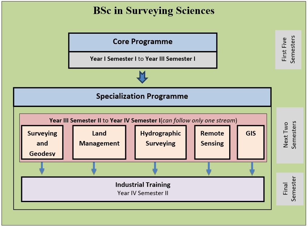
The faculty offers BSc. in Surveying Sciences degree in five areas of specialization. All students entering the faculty must follow the core courses during the first five semesters. Selection for the specialization is done at the end of 3rd year 1st semester, based on personal preference and merit.
Specialization areas
The students can follow the BSc. in Surveying Sciences degree in five specialization areas specified below. The department of Surveying and Geodesy is offers courses in three specialization areas and the department of Remote sensing and GIS offers courses in two specialization areas as indicated below.
|
Specialization area |
Department |
|---|---|
|
Bachelor of Science Honours in Surveying Sciences in Surveying & Geodesy |
Surveying and Geodesy |
|
Bachelor of Science Honours in Surveying Sciences in Land Management |
|
|
Bachelor of Science Honours in Surveying Sciences in Hydrographic Surveying |
|
|
Bachelor of Science Honours in Surveying Sciences in Remote Sensing |
Remote Sensing and GIS |
|
Bachelor of Science Honours in Surveying Sciences in Geographic Information System |
All students entering the faculty must follow the sore courses during the first five semesters. Selection for the specialization is done at the end of 3rd year 1st semester, based on personal preference and merit. According to the Sri Lanka Qualification Framework (SLQF) guidelines, a Bachelor of Science Honours degree needs to offer a minimum of 120 credits. However, as the BScHons (Surveying Sciences) degree is at exit level 7 (SLQF – Sep. 2015), a student needs to complete a minimum of 150 credits to be eligible for graduation. Of these 150 credits, 113 credits come from the common but compulsory core of the programme, with the rest from selected specialization courses.
Study Mode
This Bachelor of Science Honours in Surveying Sciences degree is offered as a full time course by the Faculty of Geomatics, Sabaragamuwa University of Sri Lanka at the main campus situated at Belihuloya. Further the medium of instructions of this course is English. Refer, Faculty Hand Book for the criteria of the selection for specialization.
Selection Criteria for Specialization
The students should apply for specialization, indicating the preferences at the end of the 5th semester. However, if there are more applicants for a course than viable, examination results of the core programme will be considered. Additionally, a student needs to pass all relevant pre-requisite courses from the core programme to be eligible for his/her choice of specialization. The pre-requisite subjects will be decided by each department.
The student has to apply for his/her choice of optional courses, from the courses offered by each department, before the commencement of the new semester. Then, he/she is allowed to add or drop courses until the end of the first week of the semester, if necessary.
At the same time, a student can apply for a greater number of courses than the number of courses required to earn the prescribed minimum number of credits. In this case, the student must choose and specify the courses that are to be counted for the Final Grade Point (FGP), and the grades of the rest of the optional courses will be recorded in the detailed transcript but not counted towards the calculation of the FGP. However, all decisions are subjected to discussion and approval by the Faculty Board of the Faculty of Geomatics.
Refer, Faculty Hand Book for the proposed courses for each semester, with the appropriate number of credits per course.
Duration of study and methods
The duration of the study is:
- Minimum 8 semesters (4 years)
- Maximum 12 semesters (6 years)
The methods of teaching and learning
Directed Learning
| Lectures | Power point presentation/ Conventional delivery methods |
| Practical | Laboratory/ Field/ Demonstrations |
| Tutorial | Discussing and solving problems/questions with students |
| Student Centred Learning (SCL) | Students presenting certain topics in the curriculum, debates, homework, group/individual presentations |
| Seminar | Knowledge imparted by a resource person/expert to a ‘class’ with minimum or no practical component |
| Workshop | Knowledge imparted by a resource person/expert to a ‘class’ with the major portion comprising of hands-on experience |
Independent Learning
| SCL activities | Preparation for SCL activities in class |
| Assignments | Questions/ Quizzes/ Presentations/ Demonstrations/ Debates |
| Projects | Individual/ Group activities involving a certain topic/ activity |
| e-Learning | Use of electronic media, commonly the internet for education |
| Homework | Studies that a student has to do out of the class hours |
| Field visit | Report/ Presentations/ Viva |
| Revision/Preparation for Exams | Working through the entire curriculum by oneself (before the final examination) |
Programme Learning Outcomes (PLOs)
The basic learning outcomes that must be demonstrated by the students at the end of the programme are summarized as follows.
Description of the Learning Programme
(a) Knowledge
- An adequate theoretical knowledge to plan and conduct Geomatics related projects
- Ability to use techniques, skills & modern tools to solve Geomatics related problems effectively & creatively
- To manage geo-spatial data effectively
(b) Skills
- Ability to apply his knowledge and skills to enhance the management of the natural and anthropogenic resources for the sustainable development of the nation
- Ability to think critically and solve problems efficiently
- Ability to lead a team effectively to achieve a common goal
- Ability to communicate effectively
- Ability to apply skills in financial, operational and human resource management
- Ability to apply entrepreneurial skills effectively
(c) Attitudes
- Ability to work independently & in collaboration with others
- Care of instruments and other resources
- Intellectual integrity, respect for truth & for the ethics of research & scholarly activities
- An ability to lead the community and the willingness to accept social & civic responsibilities
- Respect the values of the other individuals and groups, and an appreciation of human and cultural diversity
- Continuous professional and personal development
Foundation Programme
Course Outline
Year I Semester I
|
* Compulsory, non-GPA subjects
**Compulsory, credited and non-GPA subjects.
Year I Semester II
|
* Compulsory, non-GPA subjects
**Compulsory, credited and non-GPA subjects.
Year II Semester I
|
Subject Code |
Subject |
Credit |
|
FC 21212 |
2 |
|
|
FC 21114 |
1 |
|
|
FC 21324 |
3 |
|
|
FC 21328 |
3 |
|
|
FC 21129 |
1 |
|
|
FC 21241 |
2 |
|
|
FC 21342 |
3 |
|
|
FC 21546 |
5 |
|
|
FC 21248 |
2 |
|
|
FC 21159 |
1 |
|
|
TOTAL CREDITS FOR YEAR II SEMESTER I |
23 |
|
Year II Semester II
|
Subject Code |
Subject |
Credit |
|
FC 22211 |
2 |
|
|
FC 22213 |
2 |
|
|
FC 22226 |
2 |
|
|
FC 22130 |
1 |
|
|
FC 22238 |
2 |
|
|
FC 22239 |
2 |
|
|
FC 22247 |
5 |
|
|
FC 22351 |
3 |
|
|
FC 22153 |
1 |
|
|
FC 22362 |
3 |
|
|
TOTAL CREDITS FOR YEAR II SEMESTER II |
23 |
|
Year III Semester I
|
Subject Code |
Subject |
Credit |
|
FC 31327 |
3 |
|
|
FC 31133 |
1 |
|
|
FC 31234 |
2 |
|
|
FC 31335 |
3 |
|
|
FC 31236 |
2 |
|
|
FC 31337 |
3 |
|
|
FC 31140 |
1 |
|
|
FC 31254 |
2 |
|
|
FC 31465 |
4 |
|
|
TOTAL CREDITS FOR YEAR III SEMESTER I |
21 |
|
Specializations at Department of Surveying and Geodesy
Course Outline
Year III Semester II
|
Subject Code |
Subject |
Credit |
|
SG 32211 |
2 |
|
|
SG 32314 |
3 |
|
|
SG 32216 |
2 |
|
|
SG 32217 |
2 |
|
|
Elective Subject* |
2 |
|
|
UP 41899 |
2 |
|
|
TOTAL CREDITS FOR YEAR III SEMESTER II - Surveying and Geodesy |
13 |
|
UP 41899 – Research Project*** – 2 credits (proposal)
***the subject will be continued into the following semester (Year IV semester I) and evaluated as a single subject at the end.
*should cover at least 2 credits from selected courses from other specializations. The selected courses will be given by the Faculty, based on the availability of resources etc. prevailing at any given time.
Year IV Semester I
|
Subject Code |
Subject |
Credit |
|
SG 41212 |
2 |
|
|
SG 41313 |
3 |
|
|
SG 41215 |
2 |
|
|
SG 41218 |
2 |
|
|
Elective Subject* |
2 |
|
|
UP 41899 |
Research Project - Part 2 (Final Project with Technical paper) |
6 |
|
TOTAL CREDITS FOR YEAR IV SEMESTER I - Surveying & Geodesy |
17 |
|
UP 41899 - Research Project*** – 6 credits (4 – thesis and 2 – research paper)
***The subject is a continuation of the previous semester and will be evaluated as a single subject with a total of 8 credits.
*should cover at least 2 credits from selected courses from other specializations. The selected courses will be given by the Faculty, based on the availability of resources etc. prevailing at any given time.
Year IV – Semester II
IT 42798 - Industrial Training** – 700 hours – 7 credits.
**Compulsory, credited and non-GPA subjects.
Year III – Semester II
|
Subject Code |
Subject |
Credit |
|
|---|---|---|---|
|
LM 32221 |
2 |
||
|
LM 32223 |
3 |
||
|
LM 32226 |
2 |
||
|
LM 32227 |
2 |
||
|
Elective Subject* |
2 |
||
|
UP 41899 |
2 |
||
|
TOTAL CREDITS FOR YEAR III SEMESTER II - Land Management |
13 |
||
UP 41899– Research Project*** – 2 credits (proposal)
*should cover at least 2 credits from selected courses from other specializations. The selected courses will be given by the Faculty, based on the availability of resources etc. prevailing at any given time.
***the subject will be continued into the following semester (Year IV semester I) and evaluated as a single subject at the end.
Year IV – Semester I
|
Subject Code |
Subject |
Credit |
|
|
LM 41122 |
1 |
||
|
LM 41224 |
2 |
||
|
LM 41225 |
2 |
||
|
LM 41228 |
2 |
||
|
LM 41229 |
2 |
||
|
Elective Subject* |
2 |
||
|
UP 41899 |
Research Project - Part 2 (Final Project with Technical paper) |
6 |
|
|
TOTAL CREDITS FOR YEAR IV SEMESTER I - Land Management |
17 |
||
UP 41899 - Research Project*** – 6 credits(4 – thesis and 2 – research paper)
*should cover at least 2 credits from selected courses from other specializations. The selected courses will be given by the Faculty, based on the availability of resources etc. prevailing at any given time.
***The subject is a continuation of the previous semester and will be evaluated as a single subject with a total of 8 credits.
Year IV – Semester II
IT 42798- Industrial Training** – 700 hours – 7 credits.
**Compulsory, credited and non-GPA subjects.
Specialization in Hydrographic Surveying
Course Outlines
Year III – Semester II
|
Subject Code |
Subject |
Credit |
|
|
HS 32331 |
3 |
||
|
HS 32337 |
3 |
||
|
HS 32235 |
2 |
||
|
HS 32236 |
2 |
||
|
SG 32217 |
2 |
||
|
UP 41899 |
2 |
||
|
TOTAL CREDITS FOR YEAR III SEMESTER II - Hydrographic Surveying |
14 |
||
UP 41899 – Research Project*** – 2 credits (proposal)
*Compulsory course from the Specialization programme in Surveying and Geodesy.
***the subject will be continued into the following semester (Year IV semester I) and evaluated as a single subject at the end.
Year IV – Semester I
|
Subject Code |
Subject |
Credit |
|
|
HS 41138 |
1 |
||
|
HS 41332 |
3 |
||
|
HS 41134 |
1 |
||
|
HS 41537 |
3 |
||
|
UP 41899 |
Research Project - Part 2 (Final Project with Technical paper) |
6 |
|
|
TOTAL CREDITS FOR YEAR IV SEMESTER I - Hydrographic Surveying |
16 |
||
UP 41899- Research Project*** – 6 credits (4 – thesis and 2 – research paper)
***The subject is a continuation of the previous semester and will be evaluated as a single subject with a total of 8 credits.
Year IV – Semester II
IT 42798- Industrial Training** – 700 hours – 7 credits
**Compulsory, credited and non-GPA subjects.
Total credits for Hydrographic Surveying specialization is 150 (113+37).
Specializations at Department of Remote Sensing and GIS
Course Outline
Year III Semester II
|
Subject Code |
Subject |
Credit |
|
|
RS 32241 |
2 |
||
|
RS 32348 |
3 |
||
|
RS 32243 |
2 |
||
|
RS 32347 |
3 |
||
|
Elective Subject* |
2 |
||
|
UP 41899 |
2 |
||
|
TOTAL CREDITS FOR YEAR III SEMESTER II - Remote Sensing |
14 |
||
UP 41899– Research Project*** – 2 credits (proposal)
*should cover at least 2 credits from selected courses from the other specializations. The selected courses will be given by the Faculty, based on the availability of resources etc. prevailing at any given time.
***the subject will be continued into the following semester (Year IV semester I) and evaluated as a single subject at the end.
Year IV – Semester I
|
Subject Code |
Subject |
Credit |
|
|
RS 41342 |
3 |
||
|
RS 41244 |
2 |
||
|
RS 41245 |
2 |
||
|
RS 41246 |
2 |
||
|
RS 41149 |
1 |
||
|
UP 41899 |
Research Project - Part 2 (Final Project with Technical paper) |
6 |
|
|
TOTAL CREDITS FOR YEAR IV SEMESTER I - Remote Sensing |
16 |
||
UP 41899 - Research Project*** – 6 credits (4 – thesis and 2 – research paper)
***The subject is a continuation of the previous semester and will be evaluated as a single subject with a total of 8 credits.
Year IV – Semester II
IT 42798- Industrial Training** – 700 hours – 7 credits
**Compulsory, credited and non-GPA subjects.
Year III Semester II
|
Subject Code |
Subject |
Credit |
|
GS 32351 |
3 |
|
|
GS 32253 |
2 |
|
|
GS 32254 |
2 |
|
|
GS 32258 |
2 |
|
|
Elective Subject* |
2 |
|
|
UP 41899 |
2 |
|
|
TOTAL CREDITS FOR YEAR III SEMESTER II – GIS |
13 |
|
***the subject will be continued into the following semester (Year IV semester I) and evaluated as a single subject at the end.
*should cover at least 2 credits from selected courses from the other specializations. The selected courses will be given by the Faculty, based on the availability of resources etc. prevailing at any given time.
Year IV Semester I
|
Subject Code |
Subject |
Credit |
|
GS 41152 |
1 |
|
|
GS 41255 |
2 |
|
|
GS 41256 |
2 |
|
|
GS 41257 |
2 |
|
|
GS 41260 |
2 |
|
|
Elective Subject* |
|
2 |
|
UP 41899 |
Research Project - Part 2 (Final Project with Technical paper) |
6 |
|
TOTAL CREDITS FOR YEAR IV SEMESTER I – GIS |
17 |
|
UP 41899 - Research Project*** – 6 credits (4 – thesis and 2 – research paper)
***The subject is a continuation of the previous semester and will be evaluated as a single subject with a total of 8 credits.
* should cover at least 2 credits from selected courses from other specializations. The selected courses will be given by the Faculty, based on the availability of resources etc. prevailing at any given time.
Year IV – Semester II
IT 42798- Industrial Training** – 700 hours – 7 credits
**Compulsory, credited and non-GPA subjects.
Evaluation Criteria
- A student following the curriculum of the Faculty of Geomatics will obtain 50% of the total mark of a course through continuous assessments including practical components (if any), and 50% through the final written examination.
- The final written exam shall be a one-hour paper for 15 lecture hours and a two-hour paper for 30 lecture hours.
- The continuous assessments shall have a minimum of five (05) assignments for a two-credit course and a minimum of three (03) assignments for a one-credit course, at least one of which is a group task.
- A student need to have 80% attendance for theory class and 80% attendance for practical classes (If there is a practical component in the subject , to be eligible to apply for the written semester examination.
- A maximum of three (03) make-up CAs for a 2-credit subject and two (02) make-up CAs for a 1-credit subject, will be conducted at the end of the lecture series. Only excused (medical certificate (submitted within 14 days) or a formal letter from university confirming participation in university activities) students are eligible to sit for the make-up CAs. In the case of a funeral, only that of the student’s parents, siblings, spouse and/or children is excused. This is the same for both CAs and semester examinations. If a student submits more than 3 medicals/excuses in the case of a 2-credit subject, and 2 in the case of a 1-credit subject, such cases will be open for discussion at the Faculty Board.
- If the absence to a semester examination is excused (medical certificate or formal letter from university confirming participation in university activities), the student will carry his/her CA marks of the respective theory subject to whenever they sit for the examination. In the case of a subject comprising a practical examination (i.e. Computer Programming etc.), the student carries his/her CA marks, practical marks and/or theory marks of that subject to whenever they face the examination.
- For a repeat (2nd or 3rd attempt) examination, CA or practical marks will not be considered. Instead, in the case where there is no practical component, 100% of the evaluation will be done through the examination paper. In the case of a subject with a practical examination, the student must sit both the practical and theory components, and 70% of the evaluation will be through the theory paper and 30% through the practical paper. Maximum grade for a repeat examination is ‘C’, that is 50 marks.
- All courses conducted as seminars/workshops are evaluated through attendance, SCL activities, and report.
- The evaluation criteria will be presented to the class by the respective lecturer/instructor as a handout on the very first day of the lecture/practical series.
- However, the final decision of the evaluation criteria of a course, if there is a requirement for any change to above, shall be taken by the Faculty Board.
- Evaluation of the Land Surveying Practical Subject
Attendance - 10%
Proper attire - 10%
Field procedure - 30%
Spot tests in Field Inspection - 10%
Plan work / Computation - 25%
Report - 15%
100%
Practical examination/Viva - Pass / Fail
- It is mandatory to obtain a PASS mark in the practical examination to obtain the final results.
- The course is evaluated using a Grade Point Average (GPA) system, and the final grade with the corresponding Grade Point (GP) is given in next Table.
The final grade and the corresponding GP
|
Final Grade |
Mark Obtained (M) |
Grade Point |
|
A+ |
M ≥ 90 |
4.0 |
|
A |
80 ≤ M <90 |
4.0 |
|
A- |
75 ≤ M < 80 |
3.7 |
|
B+ |
70 ≤ M < 75 |
3.3 |
|
B |
65 ≤ M < 70 |
3.0 |
|
B- |
60 ≤ M < 65 |
2.7 |
|
C+ |
55 ≤ M < 60 |
2.3 |
|
C |
50 ≤ M < 55 |
2.0 |
|
C- |
45 ≤ M < 50 |
1.7 |
|
D+ |
40 ≤ M < 45 |
1.3 |
|
D |
30 ≤ M < 40 |
1.0 |
|
E |
M < 30 |
0.0 |
- According to the GP obtained by the student, the GPA will be calculated as below;
where is the credit corresponding to the ith subject, and GP the grade point of the final grade of that subject.
The final GPA will be calculated as follows;
where is the total number of credits for the jth semester, and the corresponding GPA for that semester.
Any changes to the evaluation will be done by the Faculty Board of the Faculty of Geomatics, as there is a need.
Award requirements
A student who satisfies the following conditions is eligible for the award/pass of a degree in Bachelor of Science Honours in Surveying Sciences:
Be registered by the university as a candidate for the degree programme.
- Have completed the programme of studies for each semester to the satisfaction of the Senate.
- A candidate must obtain at least “D” passes for all courses in each semester, securing a minimum FGPA of 2.0.
- Shall have obtained a minimum of 'C' grades for all four Land Surveying Practical subjects.
- Must have at least a 'C' grade for all of the compulsory subjects in his/her area of specialization.
- Must complete within the prescribed course duration (i.e. within six years period)
Award of degree and classes
Pass
A student securing a FGPA ≥ 2.00, at the end of the degree programme and satisfying all requirements in the Section 4.1 is eligible to award of a degree.
First Class
Pass in Degree and obtain a FGPA not less than 3.70(i.e. FGPA ≥ 3.70)
Second Class Upper Division
Pass in Degree and obtain a FGPA between 3.30(inclusive) and 3.70 (exclusive)
(i.e. 3.30 ≤ FGPA < 3.70)
Second Class Lower Division
Pass in Degree and obtain a FGPA between 3.00 (inclusive) and 3.30 (exclusive)
(i.e. 3.00 ≤ FGPA < 3.30)
NOTE: To be eligible for Category-B certificate, students who followed the BSc. Hons (Surveying Sciences) (Hydrographic Surveying) must pass all modules specified by IBSC-S5 (Category B).